
Richard Yeomans
New Brunswick’s western border with the state of Maine has long been one of the most contested geopolitical terrains in North America. After the end of the American Revolution, and the partition of New Brunswick from the British colony of Nova Scotia, early loyalist settlers and colonial officials laboured to establish concrete claims to the territory north of the mouth of the St. Croix River. New Brunswick’s border problem was complicated by “The Commissioners who determined what river was the St. Croix,” remarked famed New Brunswick loyalist Edward Winslow in 1800, because they “were prevented even from ascertaining the Latitude & Longitude of the source.”[i] Lacking such information, land surveying along the new border depended upon Passamaquoddy knowledge of the many watersheds throughout the region. Governments in Fredericton and Boston actively engaged with Passamaquoddy First Nations and earlier settler inhabitants by collecting statements and conduction depositions so to better strengthen their respective claims to the territory. Even after the 1842 Webster-Ashburton Treaty established a political boundary agreed upon by settler and imperial states, boundary disputes continued because science-driven settler knowledge of latitude and longitude was lacking. The solution, proposed by nineteenth-century New Brunswick settlers, was the construction of an astronomical observatory that could scientifically determine the location of the border and boost the commercial development of the province. The process through which settler science supplanted Indigenous knowledge of the landscape raises important questions about the relationship between scientific knowledge and settler colonialism in New Brunswick. European sovereignty over the land was fabricated using knowledge first produced by Indigenous peoples, and later substantiated by scientific mechanisms such as observatories. With that in mind, this short essay seeks to ask how settlers invented their sovereignty along New Brunswick’s western edge, and how settler science disrupted and erased Indigenous knowledge of the landscape.
One of the clearest examples of the intersection between white settler science and settler colonial expansion in New Brunswick is located on the campus of the University of New Brunswick (UNB) in Fredericton. The oldest university in Canada, UNB has been a leader in scholarly research in northern North America for more than two centuries and is home to the first astronomical observatory in British North America: the Brydone Jack Observatory.
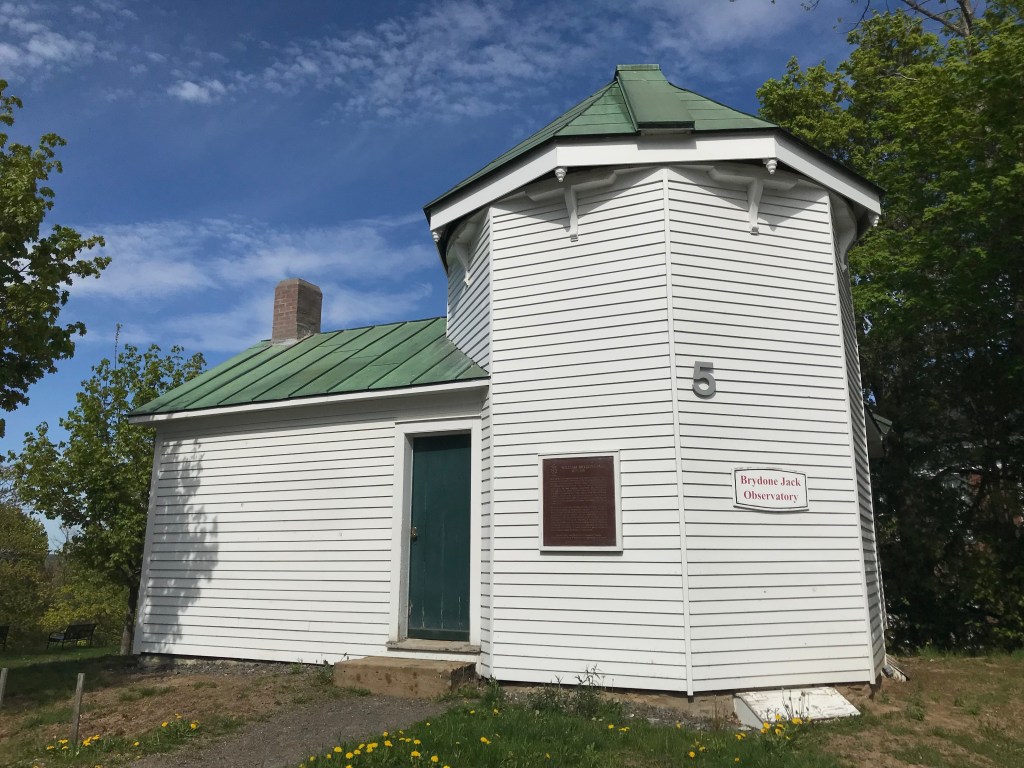
Built in 1851 next to King’s College, and designated a national historic site of Canada in 1955, the Brydone Jack Observatory has been an integral part of UNB’s campus and was significant to local and international political developments in New Brunswick prior to Confederation.[ii] Named for Scottish astronomer and natural scientists William Brydone Jack (b. 1817-d.1886), who served as UNB’s president from 1861 until 1885, both Jack and his observatory were instrumental in locating the exact longitude of Fredericton in 1855.[iii] Using this as his reference, Jack’s scientific pursuits helped to refine the New Brunswick-Maine border, and in the process, he established important links with other scientific leaders at Harvard University, such as William Cranch Bond, highlighting New Brunswick’s longstanding relationship with New England along scientific networks and over telegraphic signals.
Observatories played an important part in building a transcontinental British Empire and produced knowledge that paved the way for the commercial exploitation of Wolastoqiyik and Passamaquoddy rivers and territories in New Brunswick. How an observatory could be used to study, map, and understand land and water was central in much of the correspondence written by Jack, his colleague James Robb, and others. An observatory in New Brunswick was not just a tool meant for scientists to observe the stars and discern from them information about the world below. By mid century, the academic study of the cosmos and the magnetic composition of the earth became an important buttress to commercial enterprise on land and at sea. In an 1845 petition to the house of assembly of New Brunswick James Agnew, a Saint John watchmaker, boasted of the “great advantages that would result to the Commerce of that place by the erection of an Observatory, and praying Legislative aid toward accomplishing so desirable an object.”[iv] Agnew’s petition was tabled, but given serious attention by the legislative assembly when they commissioned the province’s naval surveyor, William Fitz William Owen, to investigate the potential for an observatory at Saint John.
In Owen’s report, he noted “The necessity of an Observatory at Saint John must be evident, at least for the purpose of obtaining the true time by the Sun.”[v]

Doing so would regulate the marine chronometers of the numerous merchant ships that traversed New Brunswick ports on route to New England, Britain, and the small islands of the Caribbean that required precise longitudes. Accurate time keeping had been key to any oceangoing voyage since the early eighteenth century, enabling the navigation of the Atlantic for thousands of European migrants and accelerating colonial expansion to unprecedented levels by 1800. “At Boston,” Owen observed, “the advantages derived therefrom to the Commerce of that Port are known to be incalculable; wrecks less frequent, navigation and commerce are rendered more secure, and commercial enterprise nourished by its silent effects.”[iv] Arguments for building an observatory in New Brunswick were often shaped by ideas derived from the discourse of public good, and for Owen such a building was comparable to the construction of lighthouses. He even suggested that monies from the Seaman’s Hospital and Light House Funds be used to front the cost, estimated at £450.
Despite Agnew and Owen’s best efforts, the Saint John observatory was never built. But the attempt to build it amplified a conversation about the utility of science and astronomy in New Brunswick, particularly as it related to the border. Writing in March of 1847, James Robb, another professor of natural science at Fredericton’s King’s College, discussed with New Brunswick’s Lt. Governor, William Colebrooke, “the subject of a magnetic and meteorological observatory at Fredericton.”[vii] The construction of an observatory in New Brunswick was becoming intricately linked to broader geopolitical questions. It was also part of the larger process behind Britain’s claim to territories across the globe. To Robb, the lack of an observatory in New Brunswick was exacerbating the problem of its border with Maine. Though the Webster-Ashburton Treaty settled the line in 1842, issues still arose over questions of jurisdiction and property ownership: particularly around the St. Croix River. “The honourable Judge Carter,” wrote Robb, and his dilemma of an over abundance of cases brought before him “wherein disputes upon the Boundary Lines arising from want of these data,” were not alleviated by the 1842 treaty.[viii] The New Brunswick-Maine border had been a cause of settler anxieties in New Brunswick for nearly three generations and Robb’s correspondence with Colebrooke picks up on this tension, especially given his proposition of an observatory as a solution to such a long-term issue. “Study and effectual means,” argued Robb, will “preserve the Colonists from falling deeper into this ‘bottomless pit of litigation’ [and] ought now to be taken.”[ix]
As early as the 1790s, cases were brought before the Supreme Court in Saint John concerning the ambiguity of New Brunswick’s political boundaries. Testimony, like that presented by James Boyd, an early inhabitant of the Passamaquoddy Bay, appears throughout the records of the province’s Executive Council and the private papers of early judiciaries such as Edward Winslow. When asked by the court if a civil “jurisdiction exercised by the government” ever presided over the St. Croix, Boyd could only answer that locals understood the border by the portage routes used by the Passamaquoddy people.[x] The colonial government in New Brunswick wanted to correct the problems caused by the American Revolution, however the settler state needed settler answers to legitimise its claim to the region. By using an observatory to refine the process of land surveying, astronomical science offered a solution that supplanted the role of Indigenous knowledge about the St. Croix River, and settler dependence upon it, in order to locate the international boundary line with the United States and assert New Brunswick’s sovereignty.
When the Brydone Jack Observatory was finally built in Fredericton in 1851, it was furnished with the most modern scientific tools of the time. Both Jack and Robb utilized the observatory, its telescope, and a host of other instruments in their teachings at King’s College (UNB).

Using these astronomical tools, colonial scientists and officials in New Brunswick sought a kind of celestial validation to their ownership of the soil that disrupted and erased Wolastoqiyik and Passamaquoddy knowledge of the landscape. Locating the ratio between magnetic north and true north made land surveying more precise and scientifically endorsed ownership of Indigenous lands by European settlers. This phenomenon, as Lorenzo Veracini’s writes, demonstrates how “settlers do not discover: they carry their sovereignty and lifestyles with them. As they move towards what amounts to a representation of their world, as they transform the land into their image.”[xi] Thinking of the Brydone Jack Observatory as an example of settler science, and a component to Veranici’s definition on settler colonialism, reveals how peoples of European descent not only carried, but also invented, their sovereignty over Indigenous lands. In New Brunswick, the application of astronomical instruments was concentrated on the development of land and sea resources, and points to just some of the silent effects of settler science and innovation in colonial space.
Innovation and science have a long history in New Brunswick, but how those developments were employed tells a story of the violent costs of modernity in settler societies. Today, institutions such as universities have begun to investigate the ways in which they shaped, and continue to shape, settler colonialism in Canada. This is being done in a variety of ways, but the largest focus has been placed on the naming of schools and campus buildings. Most recently, Dalhousie University has released its report on that school’s connections to the Atlantic slave trade, and UNB has removed George Duncan Ludlow’s name from its law school after much-heated debate, blog posts, and review by a university-formed internal committee.[xii] When intuitions such as UNB re-examine their own past, they must do more than simply question their naming practices lest they should accidently commemorate another dead racist white man. If we want to get at the root of the problem, we must ask how buildings themselves, the physical structures of settler institutions, have shaped colonialism in Canada. The answers may not be as apparent, but the process is how we move toward a broader reconciliation.
Richard Yeomans is a PhD Candidate in the Department of History at the University of New Brunswick. His research examines how nineteenth-century scientific knowledge was developed and utilized in New Brunswick. He is the website manager of Atlanticdigitalscholarship.ca, the official website for UNB’s Atlantic Canada Studies Centre.
[i] “Report on Lord Dalhousie’s History on Slavery and Race,” Dalhousie Univeristy, September 2019, https://www.dal.ca/dept/ldp/findings.html [accessed May 28, 2020]; “Working Group on the Principles of Naming or Renaming University Places Report: Phase One,” University of New Brunswick, April 9, 2020, https://www.unb.ca/initiatives/namedplaces/index.html [accessed May 28, 2020].

Latest Comments