[This is the third essay of the Borealia series on Cartography and Empire–on the many ways maps were employed in the contested imperial spaces of early modern North America.]
Lauren Beck
The Geographic Names Board of Canada (GNBC) provides scholars with a database of place names that allows users to look up the location of a place name, but that’s about all the information one can glean from this utility. The provinces provide their own toponymic research tools, and these tend to be more informative. New Brunswick, for instance, allows searchers to query a name and gives background on the name’s meaning and the town or feature’s history.
These research tools allow us to better understand our place nomenclature as well as how frequently certain names have been used across the country. Moncton, New Brunswick, also shares its place name with Sommet de Moncton in Charlevoix, Quebec, and the toponym appears in two street names located in this second province. The Commission de toponymie’s database also details the origins of Quebec’s place names; for the Sommet de Moncton, the database entry explains that:
Cette entité géographique est située dans un secteur où plusieurs sommets sont identifiés par des noms rappelant des lieux où ont été tenus des Sommets de la francophonie. On évoque ici la ville de Moncton, au Nouveau-Brunswick, où s’est déroulé le VIIIe Sommet de la francophonie en septembre 1999. Ce sommet s’élève à 1038 m au nord du sommet de Hanoï et à l’est de la rivière du Chemin des Canots.
Not mentioned in this explanation is the origin of the name Moncton beyond its use as a commemorative place name for the city of Moncton, New Brunswick, and the Francophone summit that took place in that city in 1999. This city’s name celebrates the activities and presence of Robert Monckton (1726-1782), the British military and administrative official who deported the Acadians from the region in 1755, helped to lead the Battle of Quebec in 1759, and was a key participant in the French and Indian War.
With the recent removal of monuments celebrating the likes of Edward Cornwallis (1713-1776) in Halifax, Nova Scotia (he levied a bounty on Mi′kmaq scalps; at present there are eight place names celebrating him located in five provinces and territories) and John A. MacDonald (1815-1891) in Victoria, British Columbia (he helped to create the Indian Act and the residential school system; there are 134 place names spread across the country with the name MacDonald, although it remains unclear how many specifically commemorate the prime minister), a pressing question surfaces: should Canada and the provinces revise our toponymy as well?
Names such as Moncton also elevate primarily white, masculine figures to the level of the place nomenclature that celebrates and commemorates them. When we study the names bestowed during the early modern period upon Canada’s fourteen capital cities, we furthermore observe that even when names remember women, in the case of Charlottetown, Prince Edward Island, they were nonetheless chosen and given by white men; in the case of this last city, the British Surveyor-General Captain Samuel Holland selected the name in honour of George III’s wife, Charlotte. Nearby in New Brunswick and initially called Ste. Anne’s Point, the settlement now known as Fredericton was renamed Frederickstown in 1785 by then-governor Thomas Carleton. This change demonstrates how space can be masculinized even when the intention was likely to curry the political favour, in this case, of the Duke of York, Prince Frederick (Figure 1).

Figure 1. This map shows the coexistence of St. Anne and Fredericton as place names for a settlement two years after the renaming of Ste. Anne had taken place. Robert Campbell and Samuel John Neele, A map of the great river St. John & waters (the first ever published) from the Bay of Fundy, up to St. Anns or Frederick’s Town; being little known by white people, until 1783; settled by the American Loyalists, then part of Nova Scotia, now called New Brunswick from an actual survey, made in the years 1784, 85, 86 and 87 (London?, 1787). Library of Congress, Washington, DC, G3732.S3 1787 .C3.
At odds with this place-naming practice are Indigenous and Inuit approaches to bestowing names upon features and settlements. Unlike Europeans and settlers in Canada, Indigenous names tend to be descriptive of the place and almost never commemorate individuals. Thus, when examining the subject of gendered toponymy, Indigenous names rarely arise. The Wendat (Islanders) called their land in present-day Southern Ontario Turtle Island (Wendake); other than the two “Indian Reserves” located in Quebec—also registered as two “Village[s] des Hurons” by the province’s naming commission—there is only one name commemorating this people in the country: Wendake Beach in Simcoe, Ontario, which is a small vacation town located on Lake Huron. Jesuits assigned the name Huron, from an old French term meaning ruffian or bristle brush (thought to be inspired by the way Wendat warriors fashioned their hair), to the Wendat and their space (Figure 2). On seventeenth-century maps of the region, Lake Huron was described as the Lake of the Hurons (lac des Hurons). In contrast, 30 places feature the name Huron in some way in the provinces of Ontario, Quebec, Saskatchewan, and British Columbia. Ironically, there is in this last province a Huron Island located in the Coast Land District.
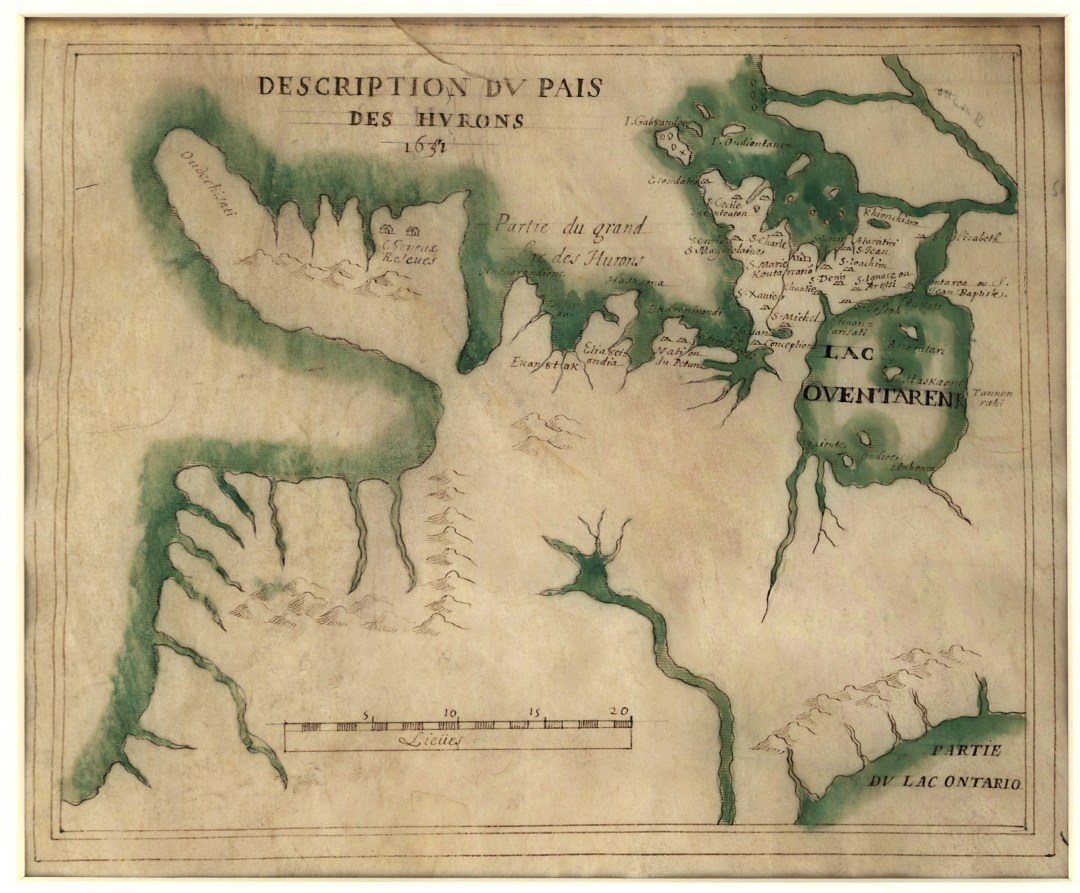
Figure 2. Notable on this map is the way toponymy represents presence within the European mindset; in this case, only the populations to which the Jesuits were ministering were represented over a 20-year period on this map. Jean de Brébeuf (attributed), Description du pais des Hurons (1631 [1651]). Parchment and ink, 20 x 25 cm. Library of Congress, Washington, DC, G3460 1651.D4.
The United States has in recent decades needed to address some of the same problems with respect to the African and African American populations and the country’s difficult history relating to race and place. One approach that the US Board on Geographic Names took in the mid-twentieth century was to address offensive names, which gave rise to many names deemed less offensive at the time. One example includes terms like Negro, which may refer to a black person or to the colour black in general in Spanish. A search of the Board’s database shows several places, such as Negro Jim Gulch in Adams County, Idaho, which still employ terms that we no longer use. Canada, too, has 13 places containing Negro. Mark Monmonier’s From Squaw Tit to Whorehouse Meadow (2006) explores the subject of inflammatory names such as this one. There remain 27 places containing Squaw in Canada.
Many commemorative names thus celebrate the presence of white men and an inversely high number of names, when they represent non-white peoples, may cause offense. One possibility is to continue updating names so that Lac-de-la-Squaw in Saguenay, Quebec becomes something more accurate, perhaps Lac-de-la-femme-Mashteuiatsh. Mashteuiatsh is a Montagnais reserve located in that region not far from the city of Roberval; this city was named for a sixteenth-century French man who tried to colonize the area.
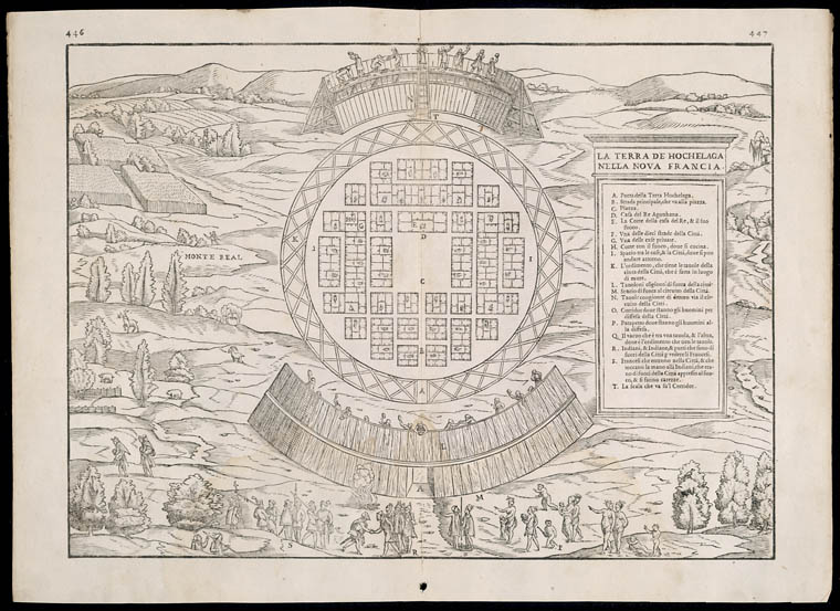
But, updating names is tricky business and, when people move, the place names often change, and names can change across languages, too. An example of this reality is Montreal, known to the Mohawk as Tiotia:ke Tsi (Broken in Two, for the way the river parts for the Island of Montreal; for this and other Haudenosaunee names, see The Decolonial Atlas). Jacques Cartier (1491-1557) knew the place by the Iroquoian name, rendered in French as Hochelaga, and of course afterward it became known by its present name. In one way, reverting to an Indigenous name seems reasonable. In another way, however, such a reversion also erases the violence of colonization. Names thus help document and remind us of the legacy of cultural incursion and genocide.
Another approach to dealing with offensive names is to shed the offensive bits. If we took Negro Creek near Cranbrook, British Columbia, whose previous name Nigger Creek was approved in 1930 and revised to its present name in 1961, and call it Black Creek, the presence of African people and of blackness as a racial typology disappears. Revising toponymy presents a significant challenge because, on the one hand, we desire more inclusive and less offensive place names, yet on the other hand, deracializing them can have the inverse effect of disappearing non-white peoples as well.
With respect to Indigenous names, there seems to be a greater appetite among naming officials as well as scholars and citizens to embrace Indigenous names for places. This does not mean, however, that non-Indigenous names are being shed, or at least not yet. When I talk about Wendake, I often must define its location using settler terminology—Southern Ontario—and because of their forced relocation to places found in Quebec and Oklahoma, I also have to qualify the period, as Wendake is manifested in different regions in different moments of time. Settler place names do not usually require this degree of clarification, which again demonstrates how difficult this subject matter and the task at hand will be.
If Canada and Canadians want to decolonize and make space for the Indigenous and Inuit peoples of this land, we will have to deal with the legacy of our place nomenclature. While we are at it, we can also think about the sexual and racial inequalities presented by existing names as well as the way through which names define communities and peoples. When it comes to Indigenous peoples, the United Nations Declaration of the Rights of Indigenous Peoples (UNDRIP) clearly states that these groups should define themselves and develop their own names. While the United Nations’ place-name commission embraces UNDRIP, and thus national naming boards also use its policies as guiding principles, at present, Canada’s toponymy does not meet this standard. Significantly, Canada has yet to endorse and adopt UNDRIP. Finally, when I last broached the subject of gender inequity in place-naming research with an official who works at one of the place-naming institutions mentioned in this essay, he admitted to not knowing how place names could be iniquitous with respect to gender.
Quite simply: this country’s toponymy must better reflect the social and cultural values of the many peoples who live here.
Lauren Beck is the Canada Research Chair in Intercultural Encounter and specializes in the early-modern Atlantic world and visual culture. In 2018, her interest in place naming practices of the Americas was supported by a Kislak Fellowship at the Library of Congress, Washington, DC, and the James Ford Bell Fellowship at the University of Minnesota in Minneapolis.
Featured Image: La Terra de Hochelaga nella Novia Francia [The Earliest Plan of Montreal ca. 1550], Library and Archives Canada, Acc. No. R9266-3417 Peter Winkworth Collection of Canadiana.
